Published on: 1/03/25 2:53 PM by Oliver (Climb Torridon)
Navigating Torridon’s Majesty: Thrilled to Partner with Harvey Maps!
Here at Climb Torridon, we’re really excited to announce our participation in the Harvey Maps Working Together Scheme! For years, we’ve relied on Harvey Maps to guide our clients through the breathtaking, challenging, and utterly unforgettable landscapes of Torridon. Now, to be officially partnered with a company whose maps are essential to our work, feels like a perfect fit.
Some of the Harvey Map products we really like:
British Mountain Maps 1:40k Torridon and Fisherfield – one map that covers a large area and is clear to use in the complex terrain around Torridon. A must for your pack.
Superwarker XT25 1:25k Skye – The Cuillin – The best map for the Cuillin Ridge on Skye. Great for exploring these wonderful mountains.
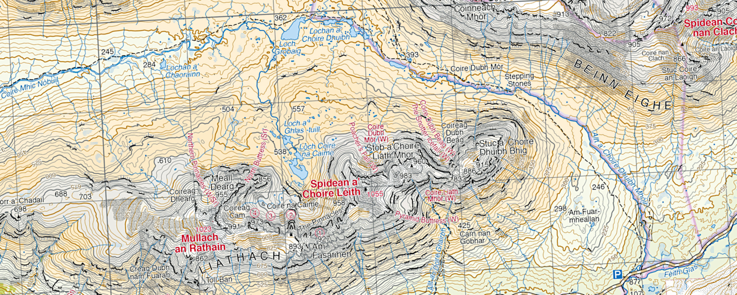
Summit Series 1:12500 Liathach Summit – clear, close up, detail for this complex hill. a great little map to use.
We’ve been using these maps daily for years. They’re the perfect tool for navigating Torridon’s complex terrain, offering a crucial balance: incredibly detailed, yet remarkably clear. Below are some of the reasons we really like them:
Why Harvey Maps Are The Best For Torridon:
Unrivalled Accuracy and Detail: Torridon’s intricate terrain demands precision. Harvey Maps are renowned for their meticulous surveying and attention to detail. The contours are clear, the paths are accurately marked, and the rock features are faithfully represented. This level of detail is crucial when navigating in challenging conditions.
Durability for the Highland Elements: Let’s face it, Torridon isn’t known for its gentle weather. Rain, wind, and even snow can be a regular occurrence. Harvey Maps are designed to withstand these harsh conditions. Their waterproof and tear-resistant paper means we can rely on them, no matter what the weather throws at us. We often back this up by using cut our sections in an Ortlieb map case. Looking after your map is essential as they are constantly being used in demanding environments.
Clarity and Readability: When you’re facing a challenging ascent or navigating a complex ridge, the last thing you need is a confusing map. Harvey Maps are designed with clarity in mind. The colours are distinct, the symbols are easy to understand, and the overall layout is intuitive. This makes navigation faster, easier, and safer, allowing us and you to focus on enjoying the experience.
Specifically Designed for Mountain Environments: Harvey Maps aren’t just general-purpose maps; they’re specifically created for mountain users. Their focus on contour detail and path accuracy makes them ideal for navigating the rugged terrain of Torridon. We find the British Mountain Map 1:40,000 Torridon and Fisherfield to be especially useful for the detail needed when guiding clients.
Being part of the Harvey Maps Working Together Scheme means we gain better access to these maps, and other products from Harvey Maps, ready to use in our courses and while we guide you over the mountains and hills around Torridon.
We’re looking forward to a long and successful partnership with Harvey Maps, sharing these maps with you and helping you make the most from them.
Come and explore Torridon with us, and see for yourself why we enjoy using Harvey Maps!
We like cookies (yum) and we hope you do to. If you continue to use this site we will assume that you are happy for us to use them on our website. We will never pass on your personal details and only use cookies to improve our offering and services not for advertising others.OKPrivacy policy